By Leslie Orloff
Dear Editor,
Attached are my thoughts about limiting gerrymandering in political districts. It is a mathematical means and should contribute to the ability to effectively limit this practice. I received no encouragement when I presented this to my congressman or senators, but I feel this approach should be encouraged by the engineering community.
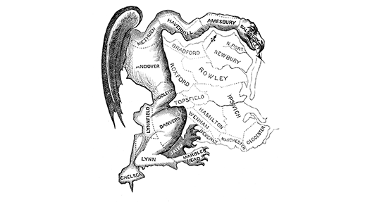
The Gerrymander is a way of aligning Election Districts to favor one political party over another. It is usually used by the party in power to discriminate over other parties not in power. It term originates from a comment made many years ago when a man named Gerry formed election districts to make his political party have an advantage over another party. One man commented that one district looked like a salamander. His companion replied “that’s a Gerrymander.” From then on a district that is formed to the advantage of one political party over another is termed a Gerrymander.
How do we prevent Gerrymanders from occurring? I have a suggestion that may not stop the process entirely, but will go a long way toward making the process much harder. I propose a rule that limits the perimeter of a district relative to its size. It is a dimensionless quantity, meaning that it does not matter what the size of the district the rule will limit its geometry. The rule is simple, it compares the perimeter, (P), squared divided by the area, (A). The rule is that this quantity must be less than 100. That is (P2/A < 100). This rule goes a long way toward inhibiting a Gerrymander from occurring.
Let’s look at the effect of this rule. The ratio of P2/A is least for a circle. For a circle the ratio is [(2*Π*r)2/Π*r2]=4*Π=12.57 approximately. A square has a ratio of (4*d)2/d2=16. A 10×1 rectangle, with a length, l, and width, w, has a ratio of (2*l+2*w)2/(l*w)2=48.4. It is hard to make a district with regular boundaries that is less than 100. This rule should subject to all electoral districts in the near future, perhaps when the census of 2020 forces the districts to be changed.
There are of course some considerations of perimeter that have to be changed. These occurrences come as a result of coastlines that are obviously irregular, state lines that may be on a river, or irregular layout, and islands that form a part of the district. The area is obviously a fixed quantity, but the perimeter, on these occasions, must be modified. I would propose a rule that on any state boundary the perimeter could be modified to extend across the straight line, outside of the boundary of the district, but tangent to the district at appropriate places. If a river is used as a boundary, not at a state line, then the same straight line, outside the district, should be used to form the perimeter. If Islands are part of a district, then the area of the island should be included in the area of the district, but the requirement of the perimeter to enclose the district should be modified to not include the islands in the perimeter.
The selection of the limit of 100 for P2/A is obviously arbitrary. There may be a different selection made for this number, but it should not be so high that it is meaningless. I would think a value of 150 would not be unreasonable but I would not go much above that. I took a look at the boundaries of counties within a state to arrive at the 100 number. I could not find a county within a state that had a ratio of greater than 100. My search was not exhaustive but I looked for irregular counties in a number of states and I could not find even one that exceeded 100. The counties are not decided by any political considerations and thus may be made to conform to the landscape.
My writing did not come out as I had hoped. Whenever you see a 2, except before a Π, it should be shown as superscript. It is on the original word file, but it did not come out when the file was transferred.
